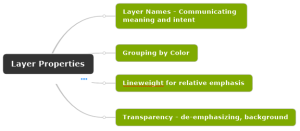
The primary purpose of layers in a CAD file is to set the visual qualities of drawing content. However, in this post I want to focus on how layers are used to convey meaning. This post addresses Name, Color, Linetype, Lineweight, and Transparency.
The primary purpose of layers in a CAD file is to set the visual qualities of drawing content. However, in this post I want to focus on how layers are used to convey meaning. This post addresses Name, Color, Linetype, Lineweight, and Transparency.
If you are an AutoCAD user doing 2D drafting you can set Object Snaps to ignore the elevation when snapping to objects not at elevation zero. You must set OSNAPZ system variable to 1. If you are a BricsCAD user doing 2D drafting just toggle the ESNAP setting “Ignore Entity Snap Elevation” ON. The screenshot […]
Learn how to add a customized toolbar in BricsCAD called Area SF. You will also learn how to add a tool to the toolbar that runs a macro, putting several commands together to complete the task of labeling the area of a close polyline.
As simple as ATTACH. BricsCAD v25 Pro will detect a world file and populate the Attach Raster Image dialog with Insertion Point coordinates (X,Y, not Z), Scale X and Y, and Rotation Angle. Insert (tab)>References (panel)>Attach. The Select Reference file dialog opens. Browse and select an image file. The Attach Raster Image dialog opens. As […]

Recent Comments